The extent of Green Belt Land
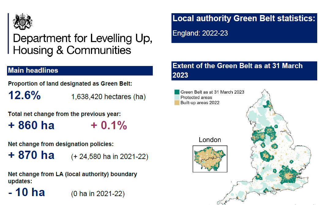
The extent of land designated as Green Belt in England as of 31 March 2023 was estimated at 1,638,420 hectares (circa 4,048,623 acres, around 12.6% of the land area).
Overall, there was an increase of 860 hectares (2,125 acres) (0.1%) in the area of land designated as Green Belt between 31 March 2022 and 31 March 2023.
In 2022-23, 10 local authorities adopted new plans involving changes to their Green Belt, with the result being a net increase of 870 hectares (2,150 acres) in the overall area of land designated as Green Belt compared to 31 March 2022.
In addition, updates to the local authority district (mean high water mark) boundaries resulted in a net decrease of 10 hectares in the area of land designated as Green Belt.

Context of those figures compared to developed land
England has a land area of just under 13,046,230 hectares of which 9% is of developed use with around 11% being classified as ‘built-up’.
When including land designated as Green Belt, just over 37% of the area of England (4.9 million hectares) is protected against development by one or more protected area.
‘Protected areas’ for these purposes include land designated as Green Belt, and the protected areas and land designations identified by the Joint Nature Conservation Committee.
The purpose of the Green Belt
- to check the unrestricted sprawl of large built-up areas
- to prevent neighbouring towns merging into one another
- to assist in safeguarding the countryside from encroachment
- to preserve the setting and special character of historic towns
- to assist in urban regeneration, by encouraging the recycling of derelict and other urban land
Once established, Green Belt boundaries should only be altered where exceptional circumstances are fully evidenced and justified, through the preparation or updating of plans.
Strategic policies should establish the need for any changes to Green Belt boundaries, having regard to their intended permanence in the long term, so they can endure beyond the plan period.
When considering any planning application, local planning authorities should ensure that substantial weight is given to any harm to the Green Belt. ‘Very special circumstances’ will not exist unless the potential harm to the Green Belt by reason of inappropriateness, and any other harm resulting from the proposal, is clearly outweighed by other considerations.


